


LOS ANGELES COUNTY METROPOLITAN TRANSPORTATION AUTHORITY
EXECUTIVE SUMMARY
Introduction
The Eastside Transit Corridor Phase 2 Project is a vital public transit infrastructure investment that would
provide a transit connection to the existing Metro Gold Line Eastside Extension and link communities on
the eastern side of the County of Los Angeles. With the implementation of the Regional Connector Transit
Corridor project, the Metro Gold Line Eastside Extension will directly connect to the Metro Expo Line and
will be operating light rail trains between Santa Monica, Culver City, University of Southern California
(USC), downtown Los Angeles, and the Eastside by 2020, improving mobility within the project area and
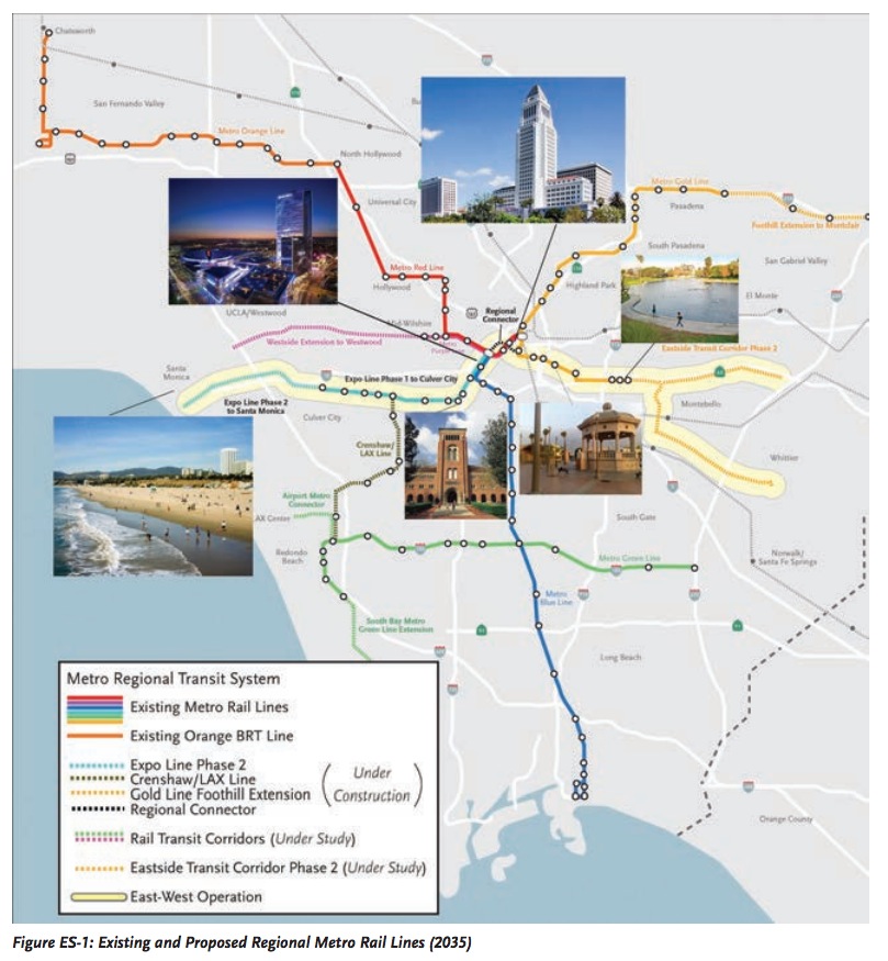
offering more sustainable transit alternatives. Figure ES-1 shows the regional Metro Rail lines expected to be
operational by the year 2035, and illustrates how the Eastside Transit Corridor Phase 2 Project would extend
the existing Metro Gold Line Eastside Extension.
The Eastside Transit Corridor Phase 2 Project would provide area residents, businesses, and transit
-dependent populations with a transit alternative connecting them to the Metro Gold Line Eastside
Extension and the regional rail system. The proposed Eastside Transit Corridor Phase 2 Project would
extend the Metro Gold Line Eastside Extension from the existing Atlantic Station to the east by 6.9 to 9.5
miles. The proposed light rail transit (LRT) build alternatives would terminate near State Route 60 (SR 60)/
Peck Road or Washington Boulevard and Lambert Road. Figure ES-1 illustrates how the Eastside Transit
Corridor Phase 2 Project would extend the existing Metro Gold Line Eastside Extension and provide access
to the Metro Blue Line, Green Line, and Red and Purple Line subways.
In addition to mobility benefits, the Eastside Transit Corridor Phase 2 Project would provide the project
area with transportation, economic, land use, and environmental benefits. The analysis presented in this
document shows that improved mobility to and from the project area has the potential to boost economic
development in the project area and improve social justice by providing better access to employment,
educational opportunities, and activity centers. Improved transit connectivity would increase transit
ridership, which would also generate environmental benefits through reduced vehicle trips, less roadway
congestion, and improved air quality.
The Eastside Transit Corridor Phase 2 Project is included in the Southern California Association of
Governments (SCAG) 2012-2035 Regional Transportation Plan/Sustainable Communities Strategy (RTP/
SCS), adopted in April 2012. The RTP also outlines several projects in and around the project area aimed at
maximizing the effectiveness, safety, and reliability of Southern California’s transportation system.
Project milestones for the Eastside Transit Corridor Phase 2 Project include:
- Publication of the Draft Environmental Impact Statement/Environmental Impact Report (EIS/EIR)
- Public review and comment on the Draft EIS/EIR (60 days following publication)
- Publication of the Final EIS/EIR – Release of the Final EIS/EIR document is based on the condition that funding is available to allow for construction of the project within three years after issuance of the Record of Decision (ROD)
- Metro Board of Directors decides to approve a project alternative and adopt a Mitigation Monitoring and Reporting Program (MMRP) and CEQA Findings
- California Environmental Quality Act (CEQA) Notice of Determination (NOD)
- Federal ROD
Following the Federal ROD, the project can proceed to final design, construction, and operation. The
schedule of these milestones will be refined as the project nears the end of the environmental review.
Purpose and Need
Purpose
The purpose of the Eastside Transit Corridor Phase 2 Project is to provide
area residents, businesses, and transit-dependent populations with a transit
alternative connecting them to the Metro Gold Line Eastside Extension and
the regional rail system.
In doing so, the project would improve mobility within the project area and
offer a more sustainable transit alternative to address increased travel demand
and projected growth, and would meet the following objectives:
- Serve the large number of transit-dependent and low-income populations in the project area;
- Increase access to major employment centers, activity centers, and destinations in the project area and Los Angeles County;
- Provide regional transit connectivity with the Metro Gold Line Eastside Extension and Measure R projects; and
- Provide transit alternatives to alleviate roadway congestion, improve mobility options for enhanced quality of life, and provide a convenient and reliable alternative to the automobile.
Need
The following mobility challenges within the project study area will continue to
grow, due in large part to population growth, if no action is taken:
- Increasing travel demand – The number of work trips taken to and from the project study area in 2006 is forecast to increase 32 percent by 2035.
- Increasing travel times – By 2035, the average peak-period travel time within the project study area is expected to increase by 25 percent and 34 percent in the morning and afternoon peak periods, respectively.
- Transit-dependent population – The project study area has a significant level of transit-dependent population who need convenient and reliable transit options to get them where they want and need to go; 38 percent of the project study area population is under age 18 or over age 65, 16 percent of households are categorized as low-income, and 12 percent of all households have zero vehicles.
- Increasing freeway congestion – With no major freeway improvements planned or funded, a growing population, and forecasted increases in travel demand, freeway congestion will continue to increase.
- Increasing arterial congestion – Major arterials in the project study area, including but not limited to Washington Boulevard and Garfield Avenue, experience heavy morning and evening peak period congestion, which negatively affects access for both automobiles and buses.
- Heavy truck traffic – The SR 60, I-5, and I-10 Freeways, along with project study area arterial streets, such as Washington Boulevard, are subject to heavy truck traffic. Larger vehicles and slower movements of heavy truck traffic on freeway and arterial streets lead to a more congested environment in which both automobiles and buses operate.
- Increasing population and employment growth – Population densities, employment densities, and the concentration of activity centers in the project study area are expected to increase by five percent for population and one percent for employment by 2035.
- Limiting travel options – With limited regional rail system connections, residents of and visitors to the project study area can rely only on available bus systems operating on the same congested roadway network. Commuter rail options are limited to two Metrolink stations within the 82-square-mile project study area.
About the Los Angeles County Metropolitan Transportation Authority
www.metro.net
Los Angeles County Metropolitan Transportation Authority (Metro) is unique among the nation’s transportation agencies. It serves as transportation planner and coordinator, designer, builder and operator for one of the country’s largest, most populous counties. More than 9.6 million people – nearly one-third of California’s residents – live, work, and play within its 1,433-square-mile service area.
Tags: CA, California, Los Angeles, Los Angeles County Metropolitan Transportation Authority
 RSS Feed