


FLORIDA DEPARTMENT OF ENVIRONMENTAL PROTECTION
FLORIDA COASTAL MANAGEMENT PROGRAM
Executive Summary
The City of St. Augustine is one of the three communities involved in the Community Resiliency Initiative Pilot Projects administered through the Florida Department of Economic Opportunity (DEO) and funded by the National Oceanic and Atmospheric Administration (NOAA). The overall effort seeks to assess community vulnerability to projected increases in coastal flooding and develop strategies to improve resilience to the associated impacts.
This report summarizes activities conducted under Task 1 of the pilot project in the City of St. Augustine – the community Coastal Vulnerability Assessment. Knowledge, material and the outputs of Task 1, summarized here, will be leveraged by Task 2 of the pilot study. Task 2 focuses on reviewing existing federal, state, and local programs and policy to provide strategy recommendations that focus on the City’s priorities and identified risks. Such strategies are intended to be integrated into the existing local planning framework.
Three types of coastal flooding were identified for analysis in the study effort. These included:
- Mean Higher High Water (MHHW), which defines the highest daily high tide, representing the limit of where land is “wetted” on a daily basis and has very limited use.
- Nuisance flooding – defined as a minor flood event that occurs monthly, often resulting in the flooding of roads.
- The 1% annual chance flood, also known as the 100-yr recurrence interval flood, which defines the Special Flood Hazard area depicted on Federal Emergency Management Agency Flood Insurance Rate Maps. Such an event has a 1% chance of occurring any given year, and a 26% chance of occurring over a 30-year timeframe.
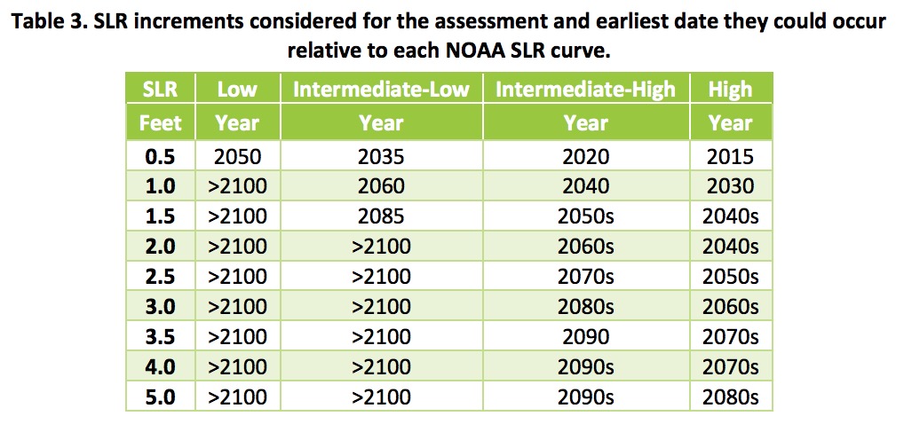
The study assessed the vulnerability of the city to these existing flood conditions with an incremental approach. This involved gradually increasing sea level at half-foot increments to identify “tipping points” in vulnerability. This approach was used to assess the city’s existing and future coastal flooding vulnerability. The study established cartographic layers of each coastal flood type and SLR scenario combination. The amount, changes in land area subject to each flood condition, and projected flooding “hotspots” were identified. The flood cartographic layers were then overlaid on the city’s GIS data to assess vulnerability of buildings, roads, bridges, water treatment facilities, as well as historical and archeological resources. The city’s vulnerability to saltwater intrusion was also evaluated. The essential results of these assessments are summarized below:
How much more flooding is expected?
- Of the three flood types evaluated, nuisance flooding has the largest potential to impact St. Augustine in the near term. An additional 500 acres of land are vulnerable to nuisance flooding with 1 ft of SLR. This scenario could occur as early as the 2030’s or as late as 2100, depending on the degree of SLR acceleration.
- Present-day areas subject to nuisance flooding are expected to be flooded almost daily by tides with 1.5 ft of SLR, which could occur as early as the 2040’s or after 2100.
- 3 ft of SLR would make today’s nuisance flood equivalent to today’s 1% annual chance flood, in terms of the area flooded. This situation could occur in the 2060’s with high acceleration, or after 2100 with low acceleration of SLR.
- The 1% annual chance floodplain is projected to increase slowly after the first 1.5 ft of SLR. At this point, the 1% floodplain inundates most of downtown St. Augustine and is relatively constrained by topographic gradients on the west side of the City.
- In addition to increased flood extent and depth, SLR also increases the frequency of coastal flood events. The future higher water day-to-day water levels allow smaller, more frequent floods to impact larger areas. For example, despite the relatively small amount of growth of the 1% annual chance flood, it is estimated that a flood equal to today’s event will occur twice as often with 1 ft of SLR.
What are the major pathways for future flooding?
- Major pathways for propagation of floodwaters into St. Augustine include the following areas, designated by streets: o Downtown: Cordova Street, vicinity of Riberia Street, King Street and Orange Street. o North: vicinity of Althea Street, Beacon Street and East Park Avenue, Ocean Boulevard, Vista Cove Road and down Douglas Avenue from the north. o East: Gerado Street, Flagler Boulevard, Arricola Avenue, Dolphin Drive and Coquina Avenue.
- Increasing flood protection where these streets come to the shoreline, or preventing backflow to these areas would reduce future flooding.
How will building vulnerability to flooding change?
- Buildings vulnerable to nuisance flooding increase by 17 fold with 1 ft of SLR.
- Buildings vulnerable to daily tidal flooding increase by 24 fold with 2.5 ft of SLR. Such a condition could occur as soon as the 2050’s or after 2100, depending on SLR acceleration.
How will road vulnerability to flooding change?
- With 1.5 ft of SLR, 30% of the road network is affected by nuisance flooding. This finding suggests that even with low levels of SLR, nuisance flooding will cause increased public inconveniences, suggesting a shift from occasional to frequent road closures. Such a condition could occur as early as the 2040s and as late as 2100, depending on SLR acceleration.
- With 3 ft of SLR, over 50% of the road network is affected by nuisance flooding, a notable finding given the frequency of this flood type. This condition is projected to occur as early as the 2060s or after 2100, depending on the degree of SLR acceleration.
- The frequency of road flooding is also expected to increase. Roads are currently only inundated for a few days out of the year – this has the potential to increase to up to 90 days a year under the 1.5 ft SLR scenario, and to 365 days with the 3.0 ft SLR scenario.
How will Historic District vulnerability to flooding change?
- Buildings located in the City’s historic districts are presently not exposed to nuisance flooding.
- Vulnerability is projected to increase with 1 to 1.5 ft of SLR, a condition that is projected to occur between the 2040s and 2100.
- In such a scenario, 20-50% of the structures in the Lincolnville, Model Land Company, St. Augustine Town Plan, Abbot Tract, Castillo de San Marcos, and the pending National Park Service historic districts are projected to be vulnerable to nuisance flooding.
- The most vulnerable are Castillo de San Marco, the Model Land, and the pending National Park Service districts.
How will SLR impact archeological zones and cemeteries?
- Most cemeteries and archeological zones are vulnerable to the 1% annual chance event, even under baseline conditions.
- For daily tidal flooding with SLR, most cemeteries have limited vulnerability to flooding until SLR reaches 3 ft. The vulnerability of archeological zones to tidal inundation is mixed – several sites are exposed under existing conditions. Overall vulnerability increases with SLR.
- Nuisance flooding is already impacting over 60% of designated archeological zones in the City. All designated sites will be subject to this type of flooding with 1.5 ft of SLR. On the other hand, only one of twelve cemeteries are presently exposed to nuisance flooding. – only one of 11 designated areas. This increases to 50% with 2 ft of SLR and 100% with 3.5 ft of SLR.
How will bridge vulnerability to flooding change?
- Presently, bridges and approaches are only vulnerable to flooding at the 1% annual chance recurrence interval.
- Bridges and approaches become vulnerable to nuisance flooding with 1 ft of SLR, and to daily tidal flooding at 2.5 ft of SLR.
- Approximately 50% of the city’s bridges are vulnerable to nuisance flooding with 2 ft of SLR.
How will sea level rise impact water and wastewater treatment facilities?
- The St. Augustine Water Plant is not vulnerable to any flood hazard or SLR combination examined by this study effort.
- The St. Augustine Wastewater Treatment Plant has limited vulnerability to flooding under existing conditions. Major vulnerability to the 1% annual chance event is noted with just 1 ft of SLR. The site would have increasing vulnerability to nuisance flooding with sea level increases between 2 and 4 ft. Major vulnerability to nuisance flooding becomes apparent with 5 ft of SLR.
What are the Anticipated Changes in the St. Augustine Water Table?
- The city is vulnerable to saltwater intrusion because of its location within a high-salinity zone and unique hydrogeological setting.
- St. Augustine’s local groundwater network may be useful for long-term monitoring of rising water-table driven by SLR.
Download full version (PDF): Coastal Vulnerability Assessment of St. Augustine, Florida
About the Florida Department of Environmental Protection
floridadep.gov
The Florida Department of Environmental Protection is the state’s lead agency for environmental management and stewardship, protecting our air, water and land. DEP is divided into three primary areas: Land and Recreation programs acquire and protect lands for preservation and recreation. DEP oversees 175 state parks and trails and more than 12 million acres of public lands and 4 million acres of coastal uplands and submerged lands. Regulatory programs safeguard natural resources by overseeing permitting and compliance activities that protect air and water quality, and manage waste cleanups. Ecosystem Restoration programs protect and improve water quality and aquatic resources including America’s Everglades and Florida’s springs. DEP works with communities, local governments and other agencies to protect and restore water quality and supply.
About the Florida Coastal Management Program
floridadep.gov/fco/fcmp
The Florida Coastal Management Program is based on a network of agencies implementing 24 statutes that protect and enhance the state’s natural, cultural and economic coastal resources. The goal of the program is to coordinate local, state and federal agency activities using existing laws to ensure that Florida’s coast is as valuable to future generations as it is today. Florida’s Department of Environmental Protection is responsible for directing the implementation of the state-wide coastal management program.
Tags: FL, Flooding, Floods, Florida, Florida Coastal Management Program, Florida Department of Environmental Protection, NOAA
 RSS Feed