


CAPITAL AREA METROPOLITAN PLANNING ORGANIZATION (CAMPO)
Executive Summary
The Central Texas Extreme Weather and Climate Change Vulnerability Assessment of Regional Transportation Infrastructure was one of 19 Federally-sponsored projects nationwide intended to “pilot approaches to conduct climate change and extreme weather vulnerability assessments of transportation infrastructure and to analyze options for adapting and improving resiliency.” This pilot was led by the Capital Area Metropolitan Planning Organization, or CAMPO, in partnership with the City of Austin, and features the contributions of a host of other state, regional, and local entities.
The specific purpose of this study was to assess the potential vulnerability of a limited selection of critical transportation assets in the CAMPO region to the effects of extreme weather and climate; to highlight lessons learned in the process, and to outline potential next steps toward enhancing the resilience of the region’s transportation infrastructure. The assets evaluated include roadways, bridges, and rail, and the climate-related stressors considered were flooding, drought, extreme heat, wildfire, and extreme cold (icing). Commensurate with the region’s Long-Range Transportation Plan (LRTP) – under development at the time of writing), the year 2040 was selected as the analysis horizon. The principal sections of this study are:
Transportation Data (Section 2)
Robust, multimodal transportation data are necessary to understand where critical assets are located and to help determine what vulnerabilities they may face as climate patterns change. The project team collected, compiled, and organized data in a Geographic Information System (GIS). These data informed the subsequent selection of critical assets for evaluation, and were integrated with climate projections to identify and assess extreme weather vulnerabilities.
Asset Criticality (Section 3)
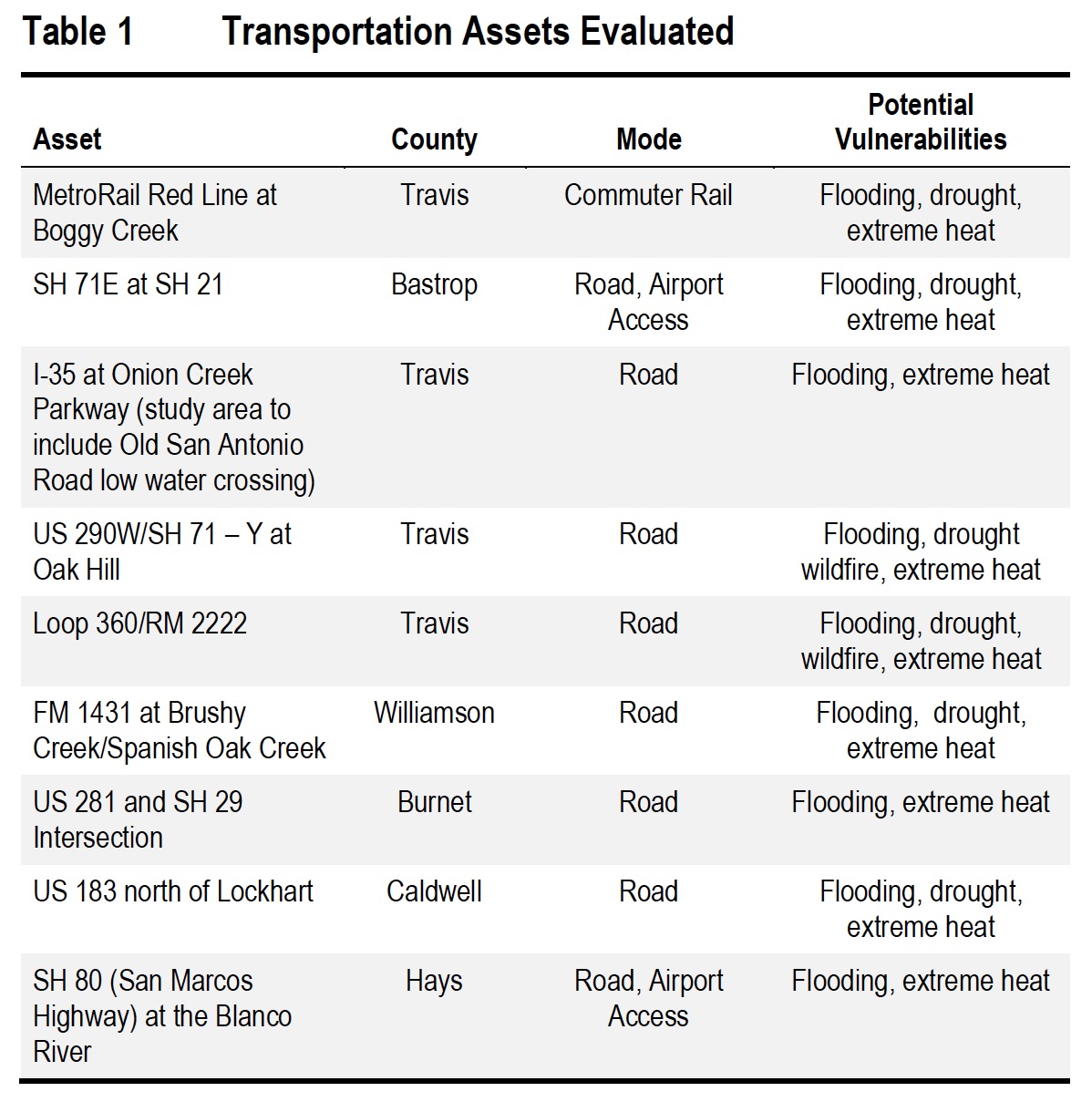
To identify assets that—if taken out of service due to extreme weather—would likely result in significant impacts, the team facilitated a workshop of regional stakeholders from the transportation sector and allied disciplines. This input helped the team identify nine critical transportation facilities for focused evaluation (see Table 1, below).
Sensitivity Thresholds (Section 4)
The team convened a series of interviews with local experts to establish the most applicable extreme weather and climate-related sensitivity thresholds for Central Texas. The goal of this exercise was to determine which climate variables to employ in the subsequent vulnerability assessment. The expert interviews included staff from TxDOT, City of Austin Public Works Department, City of Austin Department of Homeland Security and Emergency Management (HSEM), City of Austin Fire Department, Capital Metro, and Austin-Bergstrom International Airport (ABIA). These experts identified sensitivities related to five extreme weather and climate stressors—flooding, drought, extreme heat, wildfires, and extreme cold and icing. The thresholds identified were crucial to defining the climate data requirements for the subsequent vulnerability assessment.
Climate Data (Section 5)
This study leveraged previous peer-reviewed academic research to generate projections using the Weather Research and Forecasting (WRF) regional climate model (RCM), developed by the National Center for Atmospheric Research (NCAR). The team developed a series of three mid-century climate scenarios —a range of plausible futures reflecting potential climate conditions around the year 2040. The scenarios reflected projections for greater Austin and two proximate areas of Texas, one approximately 133-miles north, the other approximately 133-miles west. Although the projections for Austin are most likely, projections for neighboring regions should be considered possible for Austin as well.
Consistent with other projections for the region, the WRF model projects a warmer future for Central Texas by the middle of the 21st century: average annual temperatures are projected to rise about 2.7° F, and extreme heat events are also projected to increase (temperatures of 100° F or more are projected to increase by an average of 34 days annually). The model also projects an increase in drought conditions for Central Texas (on average, fewer days of rain annually and a potential 10 percent decrease in soil moisture)—but two of three scenarios also project more intense extreme precipitation events, such as the 25-, 50-, or 100-year rainfall.
To gauge the potential impact of increased extreme precipitation magnitudes, a hydrological model currently used by the City of Austin Flood Early Warning System (FEWS), was applied to simulate potential future flood conditions for critical assets within Travis County.
Vulnerability Assessment (Section 6)
Using the U.S. Department of Transportation (DOT) Vulnerability Assessment Scoring Tool (VAST), the team performed desktop vulnerability assessments, outputting preliminary risk ratings for all five climate stressor types for each of the nine critical assets selected for evaluation. The preliminary ratings and associated rationales were then presented to focus groups comprising state, regional, and local experts and officials (typically involving the asset owner and/or operator). Based on the feedback from focus group participants, the initial VAST results were adjusted, as needed, and finalized. The risk ratings presented in this study resulted from a planning-level screening intended to highlight potential threats to critical facilities. More in-depth evaluation would be required to justify investments to manage these risks.
This analysis highlighted a handful of key potential climate-related risks to critical CAMPO assets that may merit more detailed investigation and/or consideration of adaptive measures:
- Flooding: Flooding risk varies significantly across the assets studied, based on location and elevation relative to floodplains, condition, design standards, and other factors. SH 71/SH 21 in Bastrop County is estimated to have the highest flood risk, given the potential consequences of flooding on this critical evacuation route. The MetroRail Red Line at Boggy Creek and US 281/SH 29 also have relatively high flood risk.
- Drought: All assets are expected to be exposed to drought, as soil moisture is projected to decrease four to ten percent by mid-century. The primary determinant of drought risk is the plasticity of soils underlying a given asset, which may indicate susceptibility to shrinking and swelling with changes in soil moisture—which may in turn cause premature deterioration or damage. The MetroRail Red Line at Boggy Creek and US 183 north of Lockhart are built over the highest plasticity soils of all assets studied.
- Extreme heat: All assets are expected to be highly exposed to extreme heat. However, according to the experts consulted, the road assets studied are not expected to experience pavement damage as a result of these temperature increases. Heat poses a moderate risk to the MetroRail Red Line, because temperatures above 100° F increase the chance of thermal misalignments and force Capital Metro to issue slow orders.
- Wildfire: Wildfire risk is relatively high for all assets (except the MetroRail Red Line at Boggy Creek, which is located in a non-burnable area). Although wildfires do not typically cause physical damage to roadways, they can cause road closures or other temporary service disruptions. For many of the assets studied—particularly US 290/SH 71 and Loop 360—even small, temporary disruptions from wildfire could create bottlenecks or “choke points” that could interfere with wildfire evacuations and thus threaten human health and safety.
- Icing: Icing presents relatively low risks to all road assets, although elevated facilities are relatively more susceptible than at-grade assets. Icing events, which historically have been rare, may occur even less frequently as the century progresses.
About the Capital Area Metropolitan Planning Organization (CAMPO)
www.campotexas.org
CAMPO coordinates regional transportation planning with counties, cities, Capital Metropolitan Transportation Authority, Capital Area Rural Transportation System, Lone Star Rail, Central Texas Regional Mobility Authority, Texas Department of Transportation and other transportation providers in the region.
Tags: CAMPO, Capital Area Metropolitan Planning Organization, Central Texas, extreme weather, Resiliency, Texas, TX, Vulnerability
 RSS Feed