


NATIONAL COOPERATIVE HIGHWAY RESEARCH PROGRAM
Summary
The assessing, coding, and marking (or sometimes referred to as “posting”) of highway structures is necessary to ensure the integrity and usability of highway structures before, during, and after emergency events such as earthquakes, tsunamis, tornadoes, hurricanes, storm surge, high winds, flooding, scour, and fire. Orderly evacuation, when necessary, and subsequent emergency response require that bridges, tunnels, walls, culverts, embankments, and overhead signs be capable of safely supporting necessary loads and functioning satisfactorily. In addition, geotechnical and hydrological issues affecting these structures such as slope stability, liquefaction, settlements, and scour must also be considered.
Not only is the highway network relied upon to transport people, but it is also the economic lifeline of the affected region facilitating the movement of emergency supplies and services. Restoring power, supplying fuel, transporting injured residents, and providing food stocks can be just a few of the critical needs of a region affected by a catastrophic event.
As seen over the past few years with disastrous events such as the 2012 Hurricane Sandy and the 2011 Tohoku earthquake and tsunami in Japan, the need for emergency preparedness planning is essential to a coordinated, timely, and effective response, particularly in terms of communication between the various agencies that need to be involved. The extent of advance notice will depend on the type of event, but, in all cases, the greater the level of planning and interagency discussions that can be performed to analyze a range of what-if scenarios, the better.
One of the critical components of any emergency response plan is the process for inspectors to assess the integrity of highway structures impacted by an event. To date, a uniform methodology for rapidly assessing, coding, and marking highway structures after an emergency event does not exist. Current processes do not generally address the different highway structure types, the full range of emergency events, the range of traffic levels (i.e., the amount of traffic that a highway structure normally carries), or methods employed by other responding agencies. To this end, the primary purpose of this report is to establish a uniform methodology along with a consistent framework for coordinating the emergency response effort in a safe and efficient manner. This scalable approach provides guidance on response levels based on the severity of the event.
In fact, this recommended approach to the issue of structural assessment is based on a “First You Plan” strategy. During this vital planning phase, regional factors, interagency needs, and communication issues can be identified and addressed in a non-emergency environment. Access by inspectors to all available information (which can vary significantly) can be planned and tested under simulated event conditions (e.g., ShakeOut earthquake drills).
The assessment process presented in this report consists of four stages: Fast Reconnaissance (FR), Preliminary Damage Assessment (PDA), Detailed Damage Assessment (DDA), and Extended Investigation (EI).
This hierarchal approach accounts for the need for rapid yet reliable information at the early periods of the emergency situation followed by progressively more detail as the process continues to ensure appropriate allocation of resources during the repair and recovery phase. The approach also accounts for the diverse skill sets and capabilities of persons needed for the assessment process. Finally, it provides guidance for determining appropriate response levels and mobilization based on incoming warnings or information for each emergency event.
Given the immense scope and ranges of damages from the plethora of emergency events possible across the country, the assessment procedure was developed with a simplified taxonomy in order to group common forms of damages so that a systematic process could be implemented that is nearly independent of the hazard type.
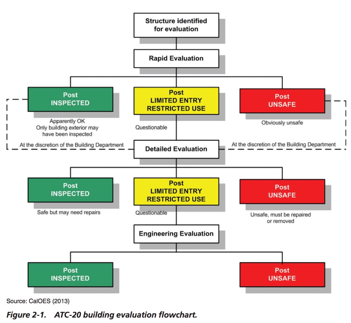
A coding and marking procedure was developed for use after the assessment is completed where each structure is physically marked with a placard and digitally marked in a database to improve communication between responders for various organizations. The coding and marking following a PDA stage establishes whether a structure has been INSPECTED or is UNSAFE. Quick-response (QR) codes are also used on these placards to link and communicate important structural or other information to field responders.
Technology is a critical component for recording and communicating these assessment results. It can help improve the process if staff are appropriately trained and prepared to utilize the technology. For example, a geographic information system (GIS) database for the structures that was prepared (and continually updated) prior to the event can be used to help prioritize assessment routes, track progress, and analyze the condition of the highway network in order to provide decision makers with up-to-date information.
Incoming data from video networks, crowdsourcing, and other sources can be quickly collected to help determine the optimal locations to send personnel for rapid inspections. While a human-centered, visual assessment process is recommended for the PDA stage, this process can be guided and enhanced through the use of applications on smart devices that enable information to be systematically recorded and routed back to the central office. In the later stages, performing more detailed assessments can also benefit from more advanced tools and resources.
Providing PDA responders (from all responding agencies) with a uniform process will help to support the overall emergency response framework, regardless of the scale of the event. Nonetheless, it is recognized that each agency will have different capabilities, resources, organizational structures, challenges, and priorities. Hence, the assessment process was developed to identify and recommend methodologies that can be practically implemented by today’s state highway agencies, along with the training materials to support these activities.
About the National Highway Cooperative Research Program (NHCRP)
www.trb.org/NCHRP
A forum for coordinated and collaborative research, the National Cooperative Highway Research Program (NCHRP) addresses issues integral to the state Departments of Transportation (DOTs) and transportation professionals at all levels of government and the private sector. The NCHRP provides practical, ready-to-implement solutions to pressing problems facing the industry.
Tags: Emergency, National Highway Cooperative Research Program, NHCRP, Transportation Research Board
 RSS Feed