


NATIONAL PARK SERVICE
UNITED STATES DEPARTMENT OF THE INTERIOR
Executive Summary
Over the next century, warming global temperatures will present many challenges for the National Park Service (NPS) and public land managers. Rising sea level will be one of the most obvious and most challenging impacts of this warming. Even a minor increase in sea level will have significant effects on coastal hazards, natural resources and assets within national parks. To begin addressing these issues, the Program for the Study of Developed Shorelines (PSDS) at Western Carolina University (WCU) has partnered with NPS to begin an assessment of the level of exposure that park owned assets will face during a period of rising sea level.
The first phase of this collaborative project between WCU and NPS has focused on identifying NPS assets that may be threatened by a future 1 m rise in sea level within 40 coastal units. A 1 m rise in sea level can be expected to occur in the next 100 to 150 years. Many of the assets identified are already vulnerable to existing coastal hazards (erosion and storms).
This project utilized an existing database (Facilities Management Software System; FMSS) containing a comprehensive list of assets within each unit. The primary objective of this analysis was to locate each asset geospatially and identify its approximate elevation. Although this seems relatively straightforward, there are over 10,000 assets within these 40 coastal units. Therefore, a variety of methods has been used to complete the work, including the acquisition of numerous existing datasets, collaboration with park staff and field visits to locate assets.
Assets were characterized based on their overall exposure to long-term (1 m) sea-level rise and associated storm vulnerability. Therefore, each asset was placed into one of two categories based on exposure or risk: 1) high exposure or 2) limited exposure. Results from this group of coastal parks yielded over 39% of the assets designated as high exposure, with a cumulative value of over $40 billion. The majority of the high risk assets were from the SER low-lying barrier island parks; however, the NER also had over one-third of its assets designated as high exposure, many of which are historically and culturally significant to NPS. These results show that a significant portion of the assets within coastal national parks are at risk to impacts from future SLR. In fact, many of these assets are already at an extremely high risk to storm impacts, which was made evident during Hurricane Sandy. A quick reassessment of the methodology contained within this report following Hurricane Sandy suggests that we have been conservative in labeling an asset as high exposure. In other words, the assets identified in this study as being vulnerable are most certainly vulnerable, and the total is likely to be an underestimate.
Finally, this study is intended to present a broad overview of the level of exposure that NPS faces in light of rising sea level. The study paints a picture of the kinds of assets that are vulnerable and the monetary value of NPS exposure. These data are not intended to be used directly for decision making at the unit level. It is worth noting that accurate elevation data is unavailable for the vast majority of FMSS-listed assets. Collection of this data should be a future NPS priority. Efforts to complete an analysis of the remaining SLR vulnerable parks are underway.
Introduction
National Park Service (NPS) coastal units contain the last remaining large stretches of relatively undeveloped shorelines in the nation. These parks contain a wide range of natural resources, cultural resources and recreational facilities. The parks also contain infrastructure providing access to each unit. Much of this infrastructure, such as roads and trails, helps to fulfill the NPS guiding principle of excellent service to visitors and partners. Other types of infrastructure, such as lighthouses and fortifications, provide heritage education to the public, while preserving important historical landmarks. A few of these units are made up almost entirely of historic structures.
Over the next century (and beyond), more NPS resources will be exposed to and threatened by rising ocean waters. Numerous coastal units, particularly low-lying barrier parks, are already dealing with sea-level rise (SLR) threats to resources and assets, particularly roads, buildings and parking lots. Much of this infrastructure is essential to the day-to-day function of the units, including bridges, water systems, tunnels and parking lots. Also at risk to SLR are historical and cultural resources, such as lighthouses, fortifications, and archaeological sites.
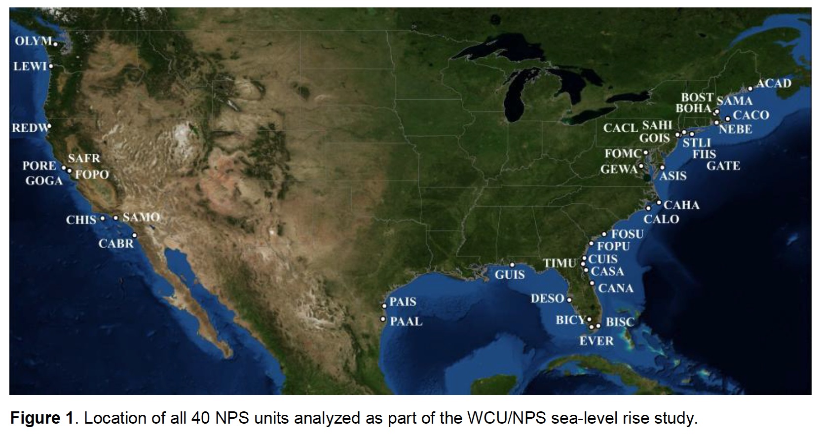
To address the SLR threats within NPS, the Program for the Study of Developed Shorelines (PSDS) at Western Carolina University (WCU) has partnered with NPS to identify resources and infrastructure at risk. To complete this task, 40 coastal units within the contiguous U.S. were chosen by NPS (Figure 1, Table 1) for analysis. The primary goal of this task was to determine the long-term SLR (1 m) exposure level of NPS assets within these units. Assets were identified from an existing NPS database (Facilities Management Software System; FMSS) and a variety of methods were used to examine the relative exposure of these assets to SLR threats.
This project was initiated with the recognition that it is important to determine the exposure of coastal park assets to climate change impacts such as SLR. The 40 parks selected for this study were covered by the USGS Coastal Vulnerability Index (http://woodshole.er.usgs.gov/project-pages/cvi/).These 40 parks were also initially included in a Sustainable Operations and Climate Change funded project that treated all assets within a park with the same level of exposure. For most parks, this is an inaccurate assumption. This study was able to determine that assets within these parks have widely varying degrees of exposure. These first 40 parks were chosen as a starting point and represent a wide range of unit sizes, habitats, natural environments, local SLR rates and unit types. A second study of an additional 30 parks is currently underway.
Download full version (PDF): Adapting To Climate Change in Coastal Parks
About the National Park Service
www.nps.gov
The National Park Service preserves unimpaired the natural and cultural resources and values of the National Park System for the enjoyment, education, and inspiration of this and future generations. The Park Service cooperates with partners to extend the benefits of natural and cultural resource conservation and outdoor recreation throughout this country and the world.
About the United States Department of the Interior
www.doi.gov
The U.S. Department of the Interior protects America’s natural resources and heritage, honors our cultures and tribal communities, and supplies the energy to power our future.
Tags: Climate Change, National Park Service, National Parks, United States Department of the Interior
 RSS Feed