


RAND CORPORATION
Summary
 Southeast Florida is particularly vulnerable to a changing climate. The highest land elevations in the region are about 12 feet above sea level. Further, the region relies on a complex network of interconnected canals and storm water management systems to manage flooding for both inland and coastal communities. These systems depend heavily on gravity to maintain positive flows and discharges to coastal waters for flood relief. As sea levels rise, discharge capacity at major control structures and storm water outfalls will be reduced if not entirely eliminated. As a result, systemwide flooding will become increasingly frequent and problematic in association with high tides, storm surge, and even moderate rainfall. Flooding will be exacerbated by rising groundwater levels as rising seas saturate the limestone aquifer that underlies Southeast Florida and thereby reduce soil storage capacity. If not well planned and coordinated, land use and transportation decisions at the local and regional levels could exacerbate impacts of a changing climate.
Southeast Florida communities already experience tidal waters spilling over seawalls, pushing up through stormwater systems, and bubbling from the ground. Over the years, groundwater levels have risen more than a foot at some locations, such that drainage wells no longer operate as designed and flood conditions appear to be more frequent and extensive. Approximately 18 salinity control structures on major canals are operating within 6 inches of their original design capacity, and at some locations, extreme high tides result in the retention of floodwaters behind closed gates. Severe rainfall events during the historically drier winter months have also produced intense flooding, delivering as much as 22 inches of rainfall in fewer than 24 hours.
Objectives
Our goals in this research were to help improve the region’s capacity to adapt to both a changing climate and changes in land use and to better understand the costs of both action and inaction across a wide range of futures. Drawing on experience in Louisiana and other coastal environments, we set out to build a transparent, interactive, and technically credible approach to decision support to assess vulnerabilities and gain insights into the potential strategies to reduce vulnerabilities under a range of climate and land use futures. Our work builds on the strong base of leadership and technical capacity already present in the region.
Our analysis addressed four questions:
- How vulnerable is current and planned future urban development in Broward County and the urban portion of Miami-Dade County (referred to as UMD) to groundwater flooding?
- What are the key drivers of future risks, including sea-level rise (SLR), precipitation, and change in economic assets?
- What areas in Broward and UMD are most at risk?
- How can different adaptation measures reduce risk?
Scope of the Analysis
Our approach began with the existing land use and economic development plans in the region. We then evaluated how a changing climate and distribution of expected population and asset growth could affect the performance of these plans. We considered alternative futures consistent with the land use plans and adaptive strategies that could reduce the identified vulnerabilities under a range of SLR and precipitation scenarios. For this process, we have drawn on the expertise within the counties’ planning departments to ensure development of realistic alternative land use scenarios.
We applied the Robust Decision Making method to this analysis. We worked with stakeholders to structure an analysis of vulnerabilities to a changing climate and increased economic growth, followed by an analysis of alternative approaches to land use that could possibly mitigate at least some of these vulnerabilities.
 How This Approach Differs from Other Efforts in the Region
Our work built on decades of observational and model-based studies to examine how groundwater in Southeast Florida may respond to a changing climate. The modeling framework summarized in Figure S.1 advances the methods of previous studies in three key aspects: (1) simulating additional climate uncertainties, (2) including future land use as an adaptation option, and (3) connecting hydrological output with economic data for a novel hydrological-economic vulnerability analysis.
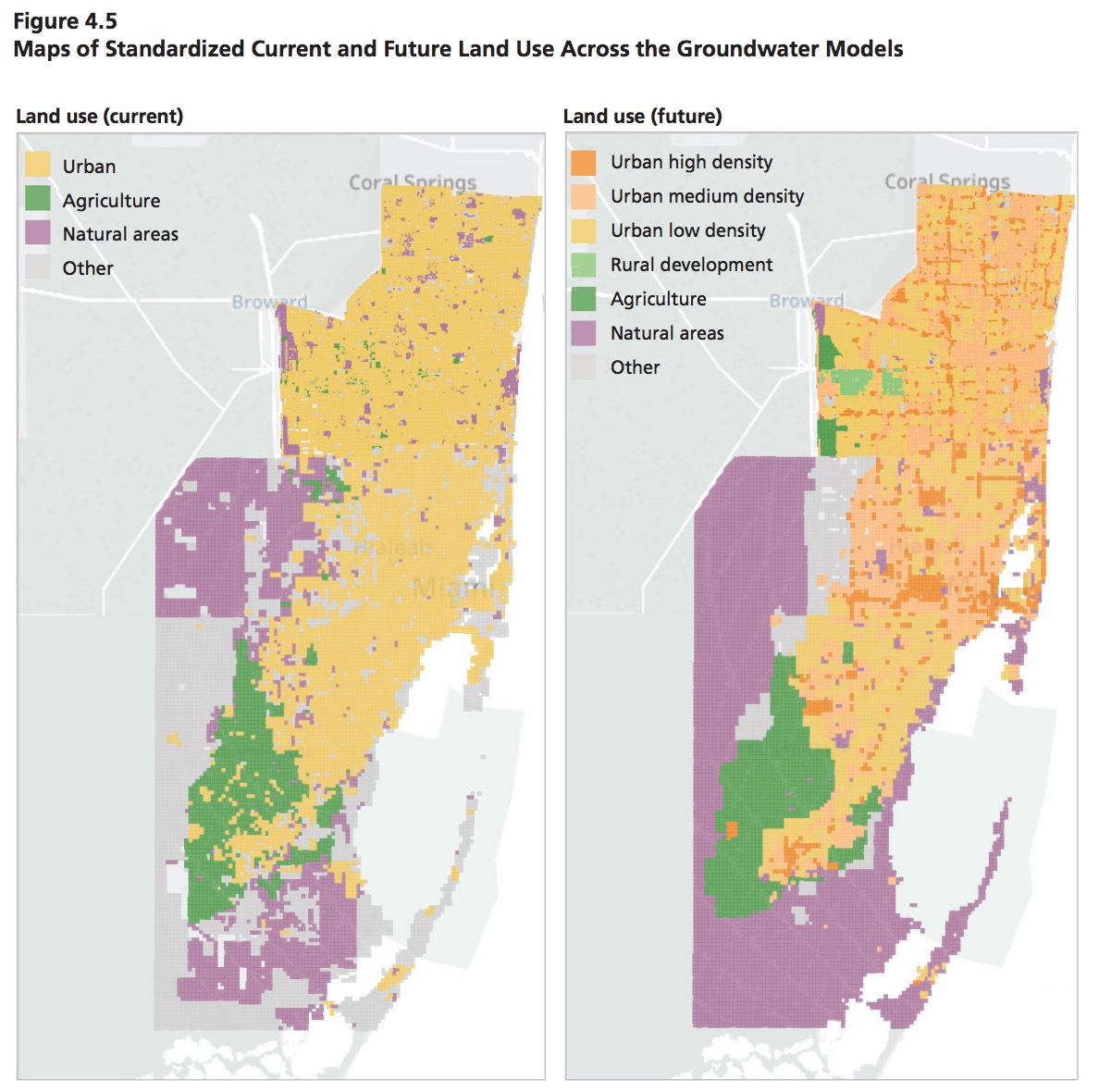
While most prior work focused only on SLR, we jointly examined the effects of future SLR and rainfall changes to groundwater elevations and salinities. To our knowledge, this research represents the first time that the UMD and Broward models have been simulated with future rainfall scenarios. Moreover, we advanced previous work by incorporating updated SLR projections into the groundwater models. We also integrated future land use plans into the hydrological modeling framework and data visualizations. This allowed us to explore how land use plans could strategically reorient development in Southeast Florida to mitigate inland flood risks. Finally, we developed novel techniques to merge economic asset valuation data with groundwater variables for a new hydrological-economic perspective on inland flood and saltwater intrusion risk in the region.
Our interest in developing an integrated modeling framework is to use it to gain insight into the vulnerability of South Florida’s built environment to a range of possible future climate conditions, land uses, and asset values.
Summary of Key Findings
Both counties are currently vulnerable to coastal flooding, and their vulnerability could increase in the future (i.e., 2040 time frame) under one or more SLR scenarios. Many inland locations are also vulnerable to flooding and could be more so under one or more future rainfall scenarios. Understanding the heterogeneity across the region should help planners and other decisionmakers better focus their efforts and funding on the areas most vulnerable to flooding and the wells most likely to be threatened by saltwater intrusion.
Our results for Broward showed the following:
- Broward is currently vulnerable to flooding in which groundwater is lifted to the surface by high tides as a consequence of low surface elevations.
- In the future (i.e., the 2040 time frame), changes in precipitation patterns could increase or decrease depth to groundwater broadly across the county. SLR will reduce depth to groundwater in coastal areas, with the highest SLR scenario leading to decreases of up to 2 feet in some areas.
- Broward has more than $12 billion of assets that are potentially vulnerable under current conditions. The value of these vulnerable assets is expected to increase between 22 percent and 45 percent by around 2040, both because of future development in currently impacted areas and because of increased hazards due to SLR and precipitation pattern changes.
- Orienting future development toward traffic analysis zones reduces future vulnerable assets by 45 percent over a development scenario that only considers elevation ($2.0 billion versus $3.7 billion).
- The remaining vulnerability due to asset growth is concentrated in three to four areas of the county, providing an opportunity for adaptation to accompany future development in these areas. Vulnerability to increased groundwater flooding hazards could affect more than $2 billion of future assets; however, $900 million of these assets would be impacted only at the highest rate of SLR evaluated.
- Saltwater intrusion has the potential to impact many groundwater wells in Broward County. Under the most favorable future (low SLR with very wet precipitation patterns), wells with replacement costs of about $40 million could be impacted by groundwater salinities that exceed 1,000 mg/L. Under the least favorable future (high SLR, very dry precipitation), wells with a total replacement cost of more than $250 million could be impacted by high-salinity groundwater.
Our results for Miami-Dade showed the following:
- UMD is much less vulnerable to tidally induced groundwater flooding than Broward, with only a few areas currently experiencing average depths to groundwater less than 1 foot, and areas along UMD’s ridge not exhibiting any vulnerability within the time frame of the analysis.
- In the future (i.e., 2040 time frame), changes in precipitation patterns could increase or decrease depth to groundwater broadly across the county, and SLR will reduce depth to groundwater in coastal areas. These changes would lead to low depths to groundwater, primarily in the coastal regions and far-western areas of UMD.
- About $2.1 billion of assets in UMD are potentially vulnerable under current conditions—a significantly lower value than in Broward. Increases in vulnerable assets by around 2040 of between about 25 percent and 270 percent of current levels are expected, both because of future development in currently impacted areas and because of increased hazards due to SLR and precipitation pattern changes.
- Directing future growth toward areas of naturally higher ground decreases future vulnerable assets by 19 percent over a development scenario that does not consider elevation ($497 million versus $614 million) (in the 2040 time frame).
- The remaining vulnerability due to asset growth is concentrated in two areas of UMD— downtown Miami and Doral—providing an opportunity for adaptation to accompany future development in these areas. About one-half of the vulnerability to increased groundwater flooding hazards would occur only under the high SLR scenario evaluated through the 2040 time frame, per the research assumptions.
- Saltwater intrusion is not projected to impact groundwater wells in UMD by the 2040 time frame.
With respect to our approach to analysis, we found the following:
- Integrating separate groundwater models developed at different times and with different grid structures, representations of land use, and salinity levels substantially complicated the analysis.
- As a first-order approximation, the economic analysis indicates a high value of assets in the region in futures that are vulnerable to SLR and changing patterns of rainfall. However, because this initial analysis accounts only for private building assets, important drivers of economic risk related to economic activity generated by commercial districts and public infrastructure are not incorporated. Future enhancements should include these important drivers of economic risk.
- Treating future land use as an uncertainty and patterns of asset growth as uncertainties is essential in any analysis of either vulnerabilities or adaptation strategies, given the many possible pathways further development might take.
- Stakeholder engagement and even more extensive interactions with decisionmakers are essential ingredients to any successful long-term planning effort.
The approach to analysis demonstrated in this project shows promise and should be continued and refined. Specifically, improvements in the UMD model would enhance analysis of Miami-Dade’s vulnerabilities and understanding of the potential effectiveness of adaptation measures. The region’s vulnerability to both SLR and increased precipitation is cause for concern, but targeted actions could reduce further exposure of assets and mitigate the effects of saltwater intrusion on drinking water supplies.
About RAND Corporation
www.rand.org
The RAND Corporation is a research organization that develops solutions to public policy challenges to help make communities throughout the world safer and more secure, healthier and more prosperous. RAND is nonprofit, nonpartisan, and committed to the public interest.
Tags: Broward County, FL, Florida, Land Use, Miami-Dade County, RAND Corporation, Southeast Florida
 RSS Feed