


DEPARTMENT OF APPLIED ECOLOGY
NORTH CAROLINA STATE UNIVERSITY
Written by Adam J. Terando, Jennifer Costanza, Curtis Belyea, Robert R. Dunn, Alexa McKerrow, Jaime A. Collazo
Introduction
Cities are expanding, and as they do urban sprawl–low-density urban development outside the urban core–is expanding even more rapidly. In some regions, expansion of suburban habitats as a result of shifts to automobile-dependent living has led to increases in the urban footprint even where populations have not shown large increases. Urban sprawl increases the connectivity among urban habitats while simultaneously fragmenting non-urban habitats such as forests and grasslands. These changes have a variety of effects on species and ecosystems, including impacts to water pollution, disturbance dynamics, local climate, and predator-prey relationships. Urban sprawl will also, almost certainly, influence the ability of species to respond to climate change, in as much as it creates barriers to the movement of species that cannot survive in cities and corridors for those who can. Knowledge about the potential future character of urban sprawl is thus useful to a variety of stakeholders, including resource managers, conservation organizations, and urban planners.
Any hope of integrating the effects of urbanization into management plans (whether for humans or wildlife), will depend on projections of urban sprawl. Such projections are typically generated using urban-growth models. The challenge is how to generate projections of urbanization that are robust enough to inform management priorities, decisions, and actions. In this regard, the challenge is similar to that faced when projecting climate change. In both cases, human actions taking place over decades will determine the outcome, and individual actions (global greenhouse gas emissions in the case of climate change; population growth, automobile dependency, and housing preferences in the case of urban growth) are difficult to predict on the time-scales of interest to decision-makers. In other words, the future as it relates to human actions has more uncertainty than what can be realistically quantified in an individual model.
A more cautious approach is to define scenarios that represent one or more particular kinds of futures, and then construct models to simulate the consequences of each scenario. For fast growing regions such as the Southeast US, the most relevant scenario for conservation and adaptation planning is the “business-as-usual” (BAU) scenario in which the net effect of growth is in line with that which has occurred in the past. While recent “Smart-Growth” initiatives that promote more intensive development and a return to a strong urban core are gaining popularity, this BAU scenario is still reflective of the primary development model. And without significant changes to the status quo, this type of growth will continue. Decision makers can use this information to see how the status quo, if continued, could affect and interact with the goals, objectives, and plans for the future.
Once the scenario is chosen, the urban-growth models typically use some combination of population density, land cover trends, and demographic models to set the parameters for the simulation. In this approach, the assumption is that changes in population lead directly to increased urbanization (by increasing density). This strategy has recently been used to project potential urban-induced threats to water quality for the U.S. and to project changes to forest stands in the Southeast. But for many regions such as the Southeast that are heavily dependent on cars, the geographic extent of urbanization (which is dependent not only on population size but also road networks and the location of often far-flung industrial and commercial activity centers), may be as relevant to conservation and other management decisions as the density of people. And because sprawling, fragmented, or “leapfrog” development has been the dominant form of development in the Southeast, population growth models may under-predict the future extent of urban areas in this region.
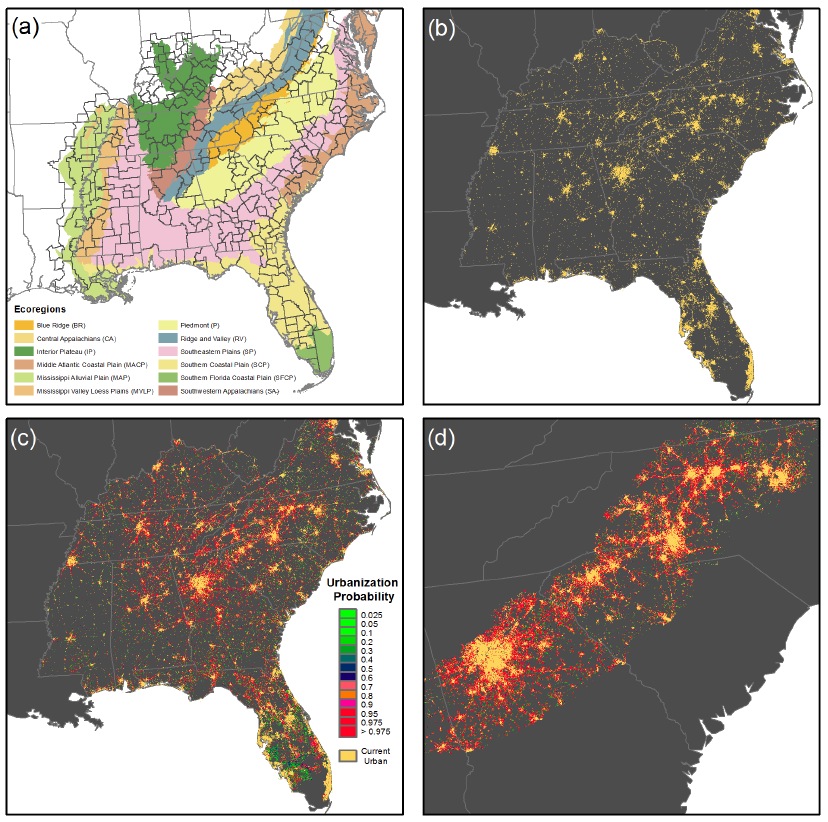
Here we project urban growth to 2060 for the Southeast U.S. for a BAU scenario using a flexible cellular automata urban-growth model that focuses on changes in the extent of urban areas rather than the density of people within them. We use the SLEUTH model, which simulates patterns of urban expansion that are consistent with spatial observations of past urban growth and transportation networks. Natural and social land use controls, such as topographic barriers or regulatory restrictions in sensitive environmental areas are specified in the model parameterization and through resistance layers that reduce the likelihood of urbanization.
More sophisticated urban growth models exist that may include more complex parameterizations or explicit links to economic and demographic theory. However, these models typically can only be used over limited spatial extents because of intensive data requirements, often reaching to the individual parcel-level. We also note that while the simpler SLEUTH model has known issues due to its structure and assumptions for how urban growth occurs, any attempt to model the dynamics of systems and phenomena as complex as cities will require a significant level of abstraction. Because our aim is to produce projections at a fine spatial resolution over a multi-state area containing many dozens of cities, we used the SLEUTH model to take advantage of its scalability, its use of commonly available datasets, and the ability to focus on patterns of suburban and exurban development.
Our modeling approach has several advantages as it relates to projecting urbanization in this fast-growing region. The primary advantage is that street networks are used to define the urban extent, allowing for accurate mapping of suburban areas and enabling rapid updates to the model as conditions change. We also use a high spatial resolution for the projections (60 m) that better corresponds to typical suburban residential lot sizes than coarser scale models (e.g., 250 m), and reflects fine-scale impacts on habitat connectivity. We also use Monte Carlo simulation to better quantify the uncertainty in the model output. As modeled here, our projections reflect the most recent trends in the expansion of low-density urban areas. As such, they represent a BAU scenario depicting how urbanization may evolve in the Southeast U.S. given current policies, preferences and rates of growth. We analyze the results with respect to three questions of importance for conservation practitioners, land managers and urban planners:
1) Given recent trends, what is the projected rate of urban growth for the next 50 years for this fast-growing region?
2) Will this growth be uniform, or will some ecosystems and land cover types be more severely impacted than others?
3) Which areas can be expected to become new growth centers?
Download full version (PDF): The Southern Megalopolis
About the NCSU Department of Applied Ecology
appliedecology.cals.ncsu.edu
The Department of Applied Ecology integrates aspects of the broader fields of biology, ecology, genetics, toxicology, conservation and living resource management into a focused unit that employs novel approaches to confront local problems and global challenges. Our faculty engage in highly collaborative research, education, and extension efforts that offer direct, practical solutions to current challenges in environmental and human well-being.
Tags: Department of Applied Ecology, NCSU, North Carolina State University, PLOS ONE, Southeast Region, sprawl
 RSS Feed