


THE INSTITUTE FOR TRANSPORTATION AND DEVELOPMENT POLICY (ITDP)
Overview
 People Near Rapid Transit (PNT) measures the number of residents in a city who live within a short walking distance (1 km) of high-quality rapid transit. This is a good way to estimate accessibility and rapid transit coverage in large cities. It is also a high-level proxy for the integration of land use and transport, and the fundamental first step toward creating inclusive transit-oriented development (TOD)—compact, higher-density, mixed-use, walkable development centered around transit stations. PNT is also the proposed indicator for the Sustainable Development Goal Target 11.2, helping to link to the SDG process and bolster action toward achieving these goals. Its simplicity and reproducibility mean the metric allows cities around the world to be quickly compared, even when data is difficult to obtain. Furthermore, visualizations of this data can highlight where new transit might be built to serve the most residents and where infill development, the development of land within an already built-up area, should be targeted to best utilize existing transit infrastructure. Finally, PNT allow cities to measure their progress over time, as new transit is built and new residents are added to the population. ITDP has assessed a number of cities around the world to compare their PNTs to one another and over time. By using PNT to understand accessibility and the integration of land use and transportation, we are able to learn what we need to do to improve our cities, making them more accessible and inclusive.
Low-density car-oriented development, often known as “sprawl,” has been the predominant urban form for cities in the past century, and the results have been disastrous for both people and the planet. This is seen in PNT, especially in metropolitan areas.
Urban population is forecasted to grow by 63% by 2050, and if trends in urban development are followed, then the total area covered by cities will triple, threatening the planet if left unguided. With the addition of 2.5 billion people, cities will have to grow. The question is how We need to come together to fight sprawl and create inclusive, compact, people-oriented cities. We need to disrupt urban development as we know it and create a new paradigm for growth for our cities.
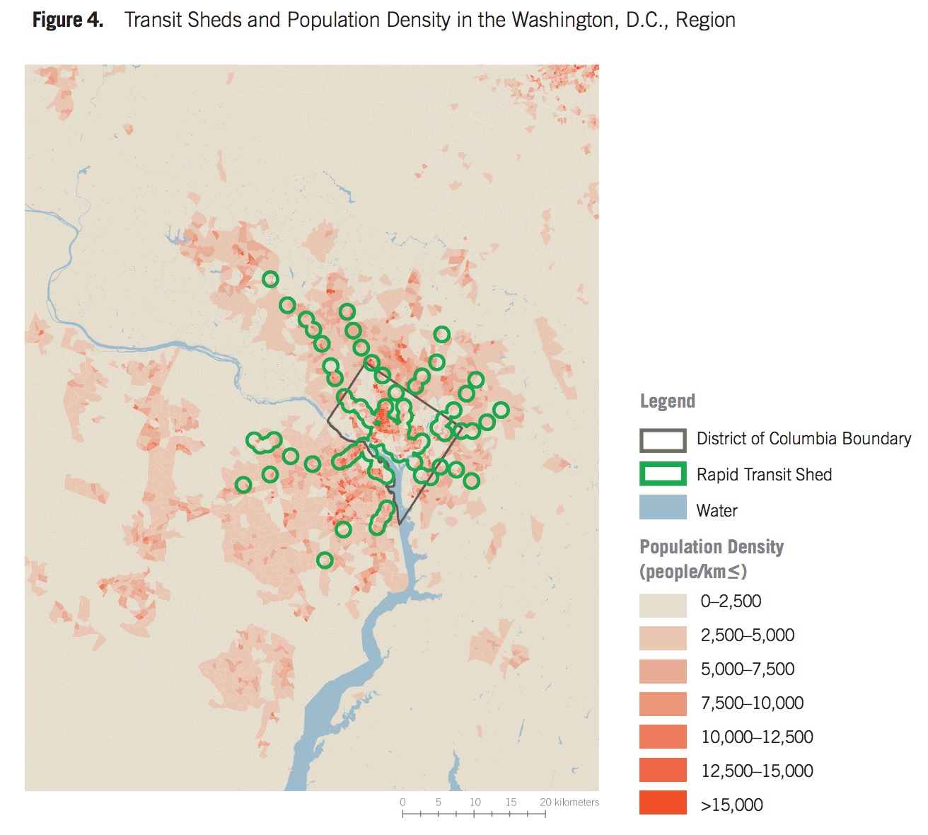
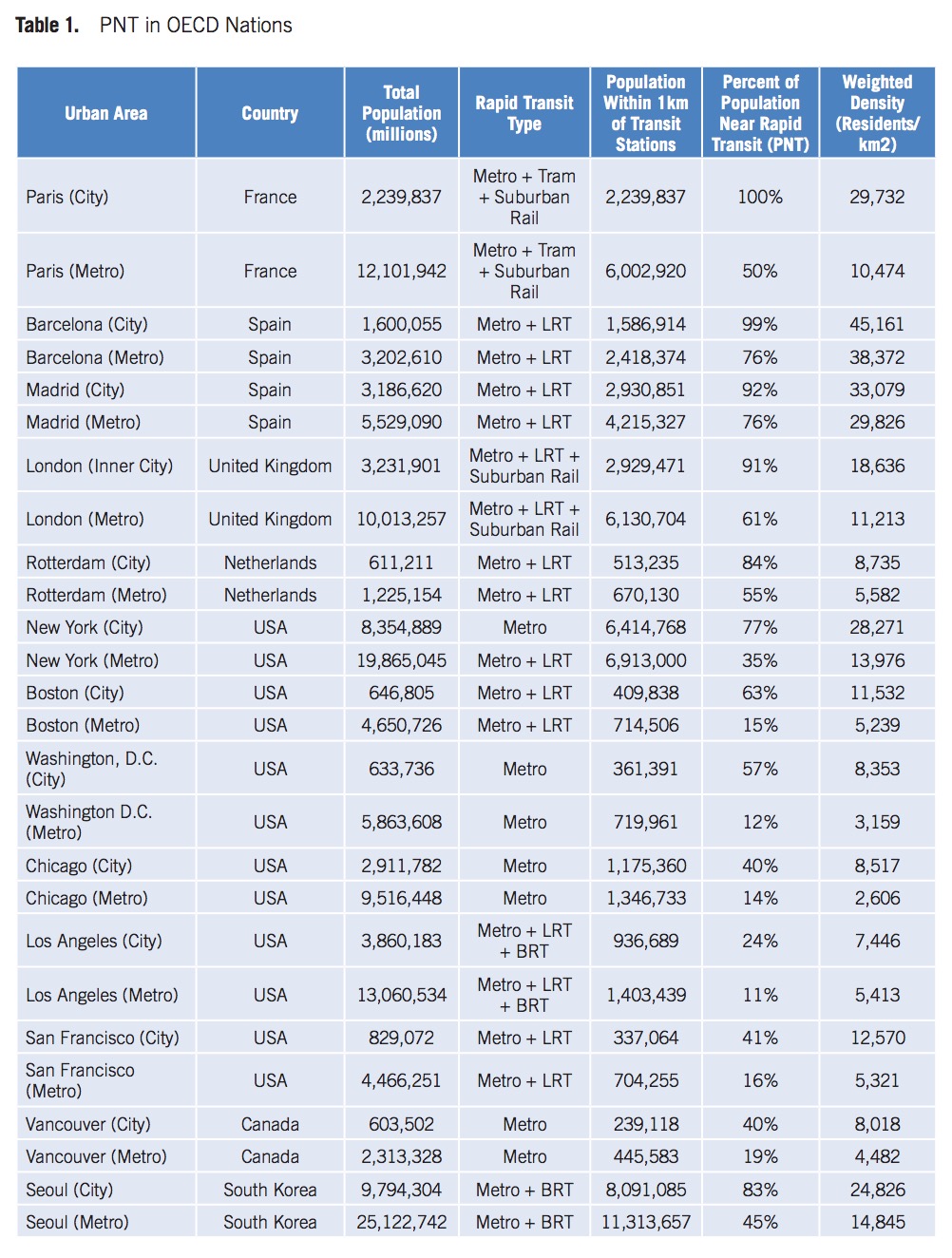
The development of the PNT indicator has yielded some meaningful findings about the intersection of urban growth and transit accessibility. One of the clearest was the difference in transit accessibility between cities and metropolitan areas. Compared to cities (within municipal boundaries), metropolitan areas as a whole show a significant drop in “accessibility”—on average by half— indicating that urban expansion is occurring faster than transit investment and perhaps in ways that undermine sustainable and equitable growth. This suggests that the urban development paradigm of expansion needs to be rethought.
Introduction
For a long time, an emphasis was placed on “mobility,” the ability to move freely, when discussing the role transportation plays in people’s lives. The ability to move freely is only valuable if that person can reach important destinations using their mobility, though. Therefore, the transportation goal that cities should be focused on is really “access” or “proximity”—residents’ ability to reach the places (work, school, shopping, etc.) they need to go to satisfy their everyday needs.
Access via rapid transit is especially important, since rapid transit is the most efficient way to transport large numbers of people around a metropolitan area. Furthermore, in addition to increasing congestion and traffic injuries and deaths, automobile-based mobility has been a leading contributor to climate change and pollution, all of which threaten the health and prosperity of city residents around the world. It is critical for cities to enable access for residents that avoids use of single-occupancy vehicles. Walking, cycling, ride-sharing, and taxis all are part of the transportation network that provides access for those without a car, and a robust public transit system with rapid transit corridors forms the backbone of that network.
For low-income residents, access to transit can mean new opportunities for jobs and less time spent commuting. Ensuring that everyone has access to transit is a critical part of making a city equitable and sustainable. ITDP is developing new and different ways to measure progress in expanding access in order to evaluate how cities around the world provide their residents with the access they require to live prosperous lives.
The concept of “accessibility” can be defined and measured in a number of different ways. Access to employment is often used as one of the most significant indicators of both economic development and effective transit. Connecting people with employment opportunities and services can be considered one of the core goals of a regional transit system. The main difficulty with this approach is acquiring location-based employment data. While accurate data is often available in high-income countries, it is much more difficult to find in low- and middle-income countries. Since the purpose of this study was to analyze transit accessibility in a variety of cities around world, we adopted the most inclusive approach possible.
This study examines a building block of overall transit accessibility: how close rapid transit is to the residents of a city. Residents of large cities need to have rapid transit options located close to where they live so they can access opportunities without using a car. Measuring the number of residents in a city or metropolitan area who are covered by rapid transit is an important barometer for the efficacy and equity of a region’s transportation infrastructure. To account for differences in city size, PNT has been calculated as “percent of population living near rapid transit.”
Calculating PNT can help find where city residents are served by public transit that is reliable, efficient, and fast. Thus, the decision to focus on rapid transit and not all mass transit was made because rapid transit can be consistently relied on by passengers to access destinations in a way that non-rapid service cannot. Rapid transit is essentially mid- to high-capacity transit that runs in a dedicated right-of-way and thus ensures a faster trip because it is not stuck in congestion. For example, a local bus that runs every 30 minutes in mixed traffic cannot be considered an effective means of accessing large sections of a big city. Therefore, creating rules for what is considered “rapid transit” is necessary to ensure that residents counted as proximate to rapid transit can truly enjoy the benefits that enhanced mobility via transit can provide. Access to rapid transit (defined in the next section) is critical, because slow and inefficient transit options are less competitive with other transport modes, particularly in large cities where distances are greater. This is amplified in cities in low- and middle-income countries, where the lack of reliable transit either greatly reduces economic opportunities or pushes residents toward less-sustainable modes, such as single-occupancy vehicles, as soon as they are able to afford them. As cities grow quickly in size and wealth, the commuting patterns that their residents develop today will define them for decades to come.
PNT can be an important indicator for urban policy-makers, as it is an effective proxy for how well a city provides its residents with rapid transit, thus allowing both policy-makers and residents to track the progress of their cities and urban areas.
…
Conclusions and Next Steps
PNT can be used as an effective indicator for cities to quickly evaluate rapid transit access and urban growth, as it indicates how many of a city’s residents are able to access opportunities using its public transit network. With limited data requirements, almost any city in the world can be assessed, and the results can be easily compared across cities. Furthermore, the spatial mapping used to calculate PNT can also be utilized to highlight where cities are succeeding in terms of providing access and where improvements can be made.
Some limitations to this approach are worth considering. The distance to transit likely overestimates the number of people who are actually within a 1 km walk of transit. In the future, this may be revised to better approximate a 1 km walk, using, for example, the street network to calculate actual walking distances. Further, PNT does not use employment locations or any sort of destinations as a factor; it only focuses on where city residents live (i.e., “origins”). For a more complete picture of transit access, it would be beneficial to also calculate the percentage of jobs that are accessible by transit. Unfortunately, while this data can often be accessed in developed countries, it is currently very difficult to find it in the developing world. Furthermore, with employment data, “Employment near Transit” (ENT) could be assessed to approximate employment accessibility in a city. This could be paired with PNT to give an even more complete picture of transit access.
In addition, PNT only considers “rapid transit,” while in many cities networks of frequent transit serve large numbers of people effectively. Future iterations of the indicator could consider people near frequent transit too.
In further refinement of the indicator, we would like to expand the analysis to more cities in different developing countries. However, unlike in developed countries, where census and geographic data is easily available, obtaining this sort of information can still present a challenge. Ongoing efforts to use satellite imagery and remote sensing to estimate population density may address some of these issues in the near future. PNT data can also be used to assess how cities have progressed (or not) over time in terms of accessibility, much like the example in Rio de Janeiro.
Finally, by assessing population along demographic lines, it is possible to calculate access among various segments of the population—for example, low-income population with access to rapid transit. This could be used to show the equity of a city’s transit system and development patterns, as in the Brazilian cases above. In the future, we plan to complete more income- and demo – graphic-based assessments in more cities around the world. All of this presents an exciting opportunity to quickly assess cities that have long been difficult to evaluate due to data limitations.
Download full version (PDF): Improving Accessibility and Rapid Transit Coverage in Large Cities
About the Institute for Transportation and Development Policy (ITDP)
https://www.itdp.org
The Institute for Transportation and Development Policy works around the world to design and implement high quality transport systems and policy solutions that make cities more livable, equitable, and sustainable…ITDP is a global nonprofit at the forefront of innovation, providing technical expertise to accelerate the growth of sustainable transport and urban development around the world. Through our transport projects, policy advocacy, and research publications, we work to reduce carbon emissions, enhance social inclusion, and improve the quality of life for people in cities.
Tags: Institute for Transportation and Development Policy, ITDP, PNT
 RSS Feed