


U.S. ARMY CORPS OF ENGINEERS
 Executive Summary
ES.1 Introduction
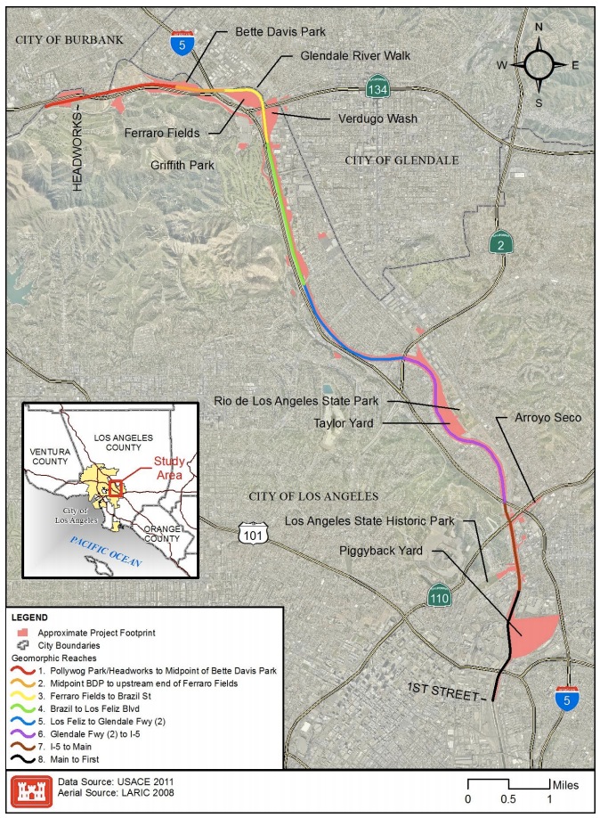
This document is an Integrated Feasibility Study, Environmental Impact Statement, and Environmental Impact Report—known as an Integrated Feasibility Report (IFR) — for the United States Army Corps of Engineers (USACE or Corps) Los Angeles River Ecosystem Restoration Feasibility Study (Study), for which the City of Los Angeles (City) is serving as non-Federal sponsor. The primary purpose of the alternative plans, including the Tentatively Selected Plan (TSP), considered in this IFR is to restore approximately 11 miles of the Los Angeles River from Griffith Park to downtown Los Angeles by reestablishing riparian strand, freshwater marsh, and aquatic habitat communities and reconnecting the River to major tributaries, its historic floodplain, and the regional habitat zones of the Santa Monica, San Gabriel, and Verdugo Mountains at this central nexus of the Los Angeles River Watershed’s former and existing ecosystems (Figure ES-1) while maintaining existing levels of flood risk management. A secondary purpose is to provide recreational opportunities consistent with the restored ecosystem within this 11-mile reach of the river. This study area is identified as the “Area with Restoration Benefits and Opportunities for Revitalization” reach, or ARBOR Reach. This reach will be referred to as the study area or ARBOR reach for the purposes of this IFR.
ES.2 Background
The Los Angeles River is the 51-milelong backbone of an 870 square mile watershed. It once anchored a vast system of riparian foothill, riverine and freshwater marsh habitat that carried seasonal rains and subterranean flows across the coastal plain to the Pacific Ocean. Over the last 150 years, the River has been degraded by a cycle of increasing urban development in the floodplain, flooding, and channelization, culminating in the mid-20th century with the construction of the Federal flood risk management project known as Los Angeles County Drainage Area (LACDA).
Like many other rivers in the Southwestern United States, much of the River was an ephemeral stream, which would appear dry for much of the year, but become a powerful torrent during the rainy season, expanding over the floodplain. Prior to development, the river’s course was fairly consistent through the San Fernando Valley, but “[o]nce the river rounded the bend of the Santa Monica Mountains at Griffith Park, however, its path became much more circuitous. Between the mouth of Verdugo Wash and the Arroyo Seco, the river spread over a broad depression two thousand feet wide, its course meandering considerably from year to year” (Gumprecht 136). Below the gap between the Elysian and San Rafael Hills, the channel widened and banks disappeared, with floodwaters able to stretch more than a mile wide (Gumprecht 136). During storm events, the river’s course could shift by as much as 90 degrees, changing its outlet from Santa Monica Bay to San Pedro Bay (see Figure ES 1). Development removed vegetation and converted floodplains to agricultural uses, vineyards, and later, residential, industrial, and commercial areas. When the railroads arrived in the 1870s, they placed tracks close along its banks, hemming the river in further, and bridges and trestles constrained and quickened flows and created barriers during major storm events. Groundwater and surface withdrawals reduced regular river flows significantly, but flood threats to the populace from the seasonal storm flows increased as development and infrastructure expanded within the river’s natural floodplain, constraining the river’s flow and removing supporting vegetation and areas for infiltration.
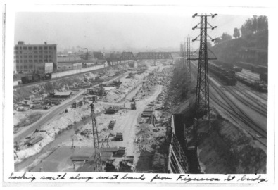
In the late 19th and early 20th centuries, storm flows in the river caused catastrophic flooding that resulted in the loss of lives and millions of dollars in property damage to areas in the river’s floodplain. As a result, City and County leaders initiated a formal flood risk management program (then known as “flood control”) to channelize the natural river system with the goal of moving flood flows to the ocean as efficiently as possible. In the 1930s, the USACE was tasked by Congress with engineering the flood risk management system, as outlined in the County’s Comprehensive Plan, which resulted in the channelization of the river and its tributaries in concrete as part of the LACDA project (Figure ES-3).
Houses, businesses, and infrastructure in the floodplain that encroached on the river channel; the increase in impervious surfaces accompanying development; and a complex system of storm drains that delivered runoff to the river made concrete channels one of the few options left at the time for effective flood risk management. “Federal flood control engineers had little choice but to confine the Los Angeles River to a relatively narrow channel, a fraction of the width of natural floodplain, because of the nature of existing development and the high price of real estate along its course.” (Gumprecht 209).
The further channelization and engineering of the already degraded river provided flood protection for the increasingly developed region and a consistent path for the River course. However, by encasing the river in concrete banks and a mostly concrete bed, widening and deepening its channel, and straightening the river’s course,1 the channelization project further diminished the river system’s plant and wildlife diversity and quality and disconnected it from its floodplain and significant ecological zones. The final section of the LACDA project in the Study Area was completed in 1959 as one component of the transformation of the region’s watersheds through development and flood risk management projects. The LACDA project continues to provide critical protection against flooding of surrounding and downstream areas and is operated by the Corps and the County of Los Angeles.
Download full report (PDF): Los Angeles River Ecosystem Restoration Integrated Feasibility Report
About the The U.S. Army Corps of Engineers
www.usace.army.mil
“The U.S. Army Corps of Engineers has approximately 37,000 dedicated Civilians and Soldiers delivering engineering services to customers in more than 90 countries worldwide. With environmental sustainability as a guiding principle, our disciplined Corps team is working diligently to strengthen our Nation’s security by building and maintaining America’s infrastructure and providing military facilities where our servicemembers train, work and live. We are also researching and developing technology for our war fighters while protecting America’s interests abroad by using our engineering expertise to promote stability and improve quality of life.”
Tags: ARBOR, CA, California, Los Angeles, Los Angeles River, U.S. Army Corps of Engineers, USACE
 RSS Feed