WASHINGTON STATE DEPARTMENT OF TRANSPORTATION
Executive Summary
Existing transportation network models assume that vehicles select the least costly path between origin and destination. This cost can entail time, distance, money, or a combination of these factors. This project used three approaches to investigate the reasonableness of this assumption and produced recommendations for revising the least cost routing approach for the state’s geographical information systems (GIS) network model.
Through this work, we also described the state of the art in freight routing software, the utility of the Washington State Department of Transportation’s (WSDOT) Global Positioning System (GPS) data for understanding routing patterns, and the routing priorities of shippers, carriers, and freight forwarders. These interim results are fully described in this report and are summarized below.
FREIGHT ROUTING SOFTWARE
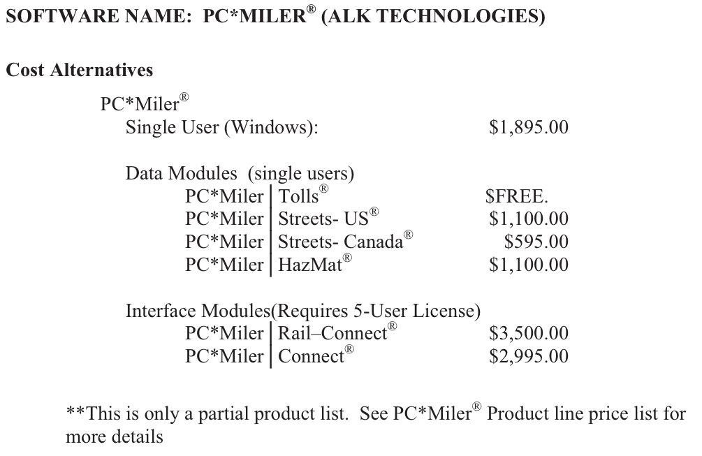
One task of this project was to conduct a review of commercially available routing and mapping software. These software programs are designed to optimize the routes of individual trucks or fleets, not to assign all trucks to routes (as a statewide freight model would do). However, their logic reveals the factors of importance to carriers when they make routing decisions. We identified routing factors and algorithms of PC*Miler, Rand-McNally, ProMiles, Prophesy, and ArcLogistics, which were found to include considerations for truck height and weight, infrastructure height and weight restrictions, toll expenses, and fuel purchasing cost. While we had assumed that some hierarchy of priorities would be built into the software, we found that this was not the case. Instead, in each case, the prioritization is left to the user. Every product examined uses a shortest path assignment, once other constraints have been met (e.g., size and weight restrictions); however, toll and fuel acquisition costs can be added to the route cost.
EVALUATION OF GPS ROUTE DATA
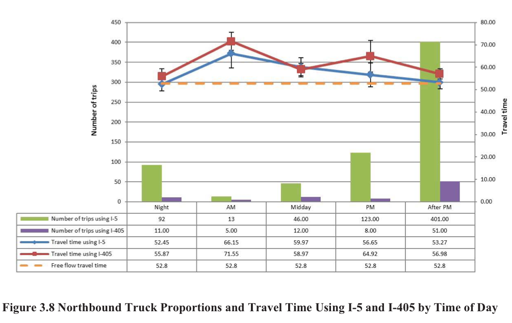
To assess the utility of using GPS truck data to improve the link-cost functions that are part of the WSDOT statewide freight model, truck travel patterns were examined. Specifically, two case studies examined route choice by time of day, system performance, and origin-destination. The case studies were selected in areas that experience congestion, with the assumption that congestion may cause route shifting behavior. We discovered that instead of route shifting, trucks in the Puget Sound exhibited strong time of day shifting behavior.
We found that because of the 15-minute intervals between reads, route diversions that occur within 20 miles of the previous route decision (the maximum assumed travel distance in 15 minutes) cannot be identified. This means that many route choice decisions within the Puget Sound, that is those where route choice decisions are possible at each block or freeway exit, remain undetected. We concluded that although GPS data are able to provide reliable transportation performance information, they are not currently sufficient for analyzing or estimating truck route choices.
ROUTING PRIORITIES
To identify routing priorities, a survey was conducted of approximately 800 shippers, receivers, and carriers of freight in Washington State. The survey was designed to find the strategies that companies use when determining routes. More specifically, its goal was to confirm or refute the least cost assumption used in existing network models. We found that overwhelmingly, respondents were meeting customer requirements, while minimizing, time, cost, or route distance. Respondents to the survey were also asked to rank the level of influence of 15 factors that influence routing decisions. After the survey had been completed, analysis of the responses included ordinal logistic regression and latent class analysis. These tools allowed us to identify the correlations between routing behavior and other characteristics of a company, such as number of trucks or primary commodity, and to group the respondents with others who had the same routing behaviors.
The analysis found five factors that differentiated among respondents and allowed us to group them into routing categories: 1) hours of service limits, 2) availability of truck parking, 3) driver availability, 4) refueling locations, and 5) road grade. Long-haul trucking, city-delivery trucking, regional trucking, the equipment companies own, and whether or not a company backhauls freight were found to be important predictors of how companies ranked the 15 routing factors and, thus, their routing category. From these results, the respondents were classified into three groups titled urban trucking, local-regional trucking, and regional long-haul trucking. These categories should be used when trips are assigned to routes on the network.
RECOMMENDATIONS
The state of Washington possesses a statewide GIS network model. Currently, if the trip origin and destination are known, the model will assign the trip to the roads that provide the shortest route between the origin and destination. Through the survey conducted for this project, we confirmed that the shortest path is overwhelmingly the appropriate logic to use once the origin, destination, and road network are known. However, the following general improvements should be made to this model logic:
Network
a. Apply a truck usable network (based on the Household Goods Mileage Guide), not the entire road network, to account for road classification.
b. When commodity data are available, hazardous material trips should be identified and relevant infrastructure restrictions captured in the network.
c. Include seasonal road closures.
d. Update speeds to reflect true travel speed obtained from the truck performance measures project, rather than the speed limit.
Objective Function
Least distance or least time should be converted to dollars so that tolls can be added to the cost of travel along a link. This will also allow emissions cost to be added to a link with an assumed emissions value.
Spatial Variation
Three categories of carriers should be reflected in the routing logic: urban trucking, local- regional trucking, and regional long-haul trucking. For carriers in these groups, the following changes should be incorporated:
a. For trips within urban regions, use the distribution of truck sizes present for those that deliver in cities and assume no backhaul.
b. For origin-destination pairs of over 300 miles, use a network that is navigable by large and heavy trucks.
c. Require origin-destination pairs that exceed 500 miles to choose routes that include a truck parking location every 500 miles (this will require documentation of truck parking locations).
Read full report (PDF) here: Improving Statewide Freight Routing Capabilities
About The Washington State Department of Transportation (WSDOT)
www.wsdot.wa.gov/
“The Washington State Department of Transportation (WSDOT) is the steward of a large and robust transportation system, and is responsible for ensuring that people and goods move safely and efficiently. In addition to building, maintaining, and operating the state highway system, WSDOT is responsible for the state ferry system, and works in partnership with others to maintain and improve local roads, railroads, airports, and multi-modal alternatives to driving.”
Tags: Improving Statewide Freight Routing Capabilities for Sub-National Commodity Flows, Washington State, Washington State Department of Transportation


 RSS Feed