


ENVIRONMENTAL PROTECTION AGENCY
Executive Summary
 The Bristol Bay watershed in southwestern Alaska supports the largest sockeye salmon fishery in the world, is home to 25 federally recognized tribal governments, and contains significant mineral resources. The potential for large-scale mining activities in the watershed has raised concerns about the impact of mining on the sustainability of Bristol Bay’s world-class commercial, recreational, and subsistence fisheries and the future of Alaska Native tribes in the watershed, who have maintained a salmon-based culture and subsistence-based way of life for at least 4,000 years.
The U.S. Environmental Protection Agency (USEPA) launched this assessment to determine the significance of Bristol Bay’s ecological resources and evaluate the potential impacts of large-scale mining on these resources. It uses the well-established methodology of an ecological risk assessment, which is a type of scientific investigation that provides technical information and analyses to foster public understanding and inform future decision making. As a scientific assessment, it does not discuss or recommend policy, legal, or regulatory decisions, nor does it outline or analyze options for future decisions.
This assessment characterizes the biological and mineral resources of the Bristol Bay watershed. It is intended to increase understanding of potential impacts of largescale mining on the region’s fish resources and serve as a technical resource for the public and for federal, state, and tribal governments as they consider how best to address the challenges posed by mining and ecological protection in the Bristol Bay watershed. It will inform ongoing discussions of the risks of mine development to the sustainability of the Bristol Bay salmon fisheries and thus will be of value to the many stakeholders in this debate.
The assessment also will inform the consideration of options for future government action, including, possibly, by USEPA, which has been petitioned by multiple groups to address mining activity in the Bristol Bay watershed using its authority under the Clean Water Act (CWA). Should specific mine projects reach the permitting stage, the assessment will enable state and federal permitting authorities to make informed decisions to grant, deny, or condition permits and/or conduct additional research or assessment as a basis for such decisions. USEPA conducted this assessment consistent with its authority under the CWA Section 104(a) and (b).
Scope of the Assessment
This assessment reviews, analyzes, and synthesizes information relevant to potential impacts of large-scale mine development on Bristol Bay fisheries and consequent effects on wildlife and Alaska Native cultures in the region. Given the economic, ecological, and cultural importance of the region’s key salmonids (sockeye, Chinook, coho, chum, and pink salmon, as well as rainbow trout and Dolly Varden) and stakeholder and public concern that a mine could affect those species, the primary focus of the assessment is the abundance, productivity, and diversity of these fishes. Because wildlife in Bristol Bay are intimately connected to and dependent on these and other fishes, changes in these fisheries are expected to affect the abundance and health of wildlife populations. Alaska Native cultures have strong nutritional, cultural, social, and spiritual dependence on salmon, so changes in salmon fisheries are expected to affect the health and welfare of Alaska Native populations. Therefore, wildlife and Alaska Native cultures are also considered as assessment endpoints, but only as they are affected by changes in salmonid fisheries.
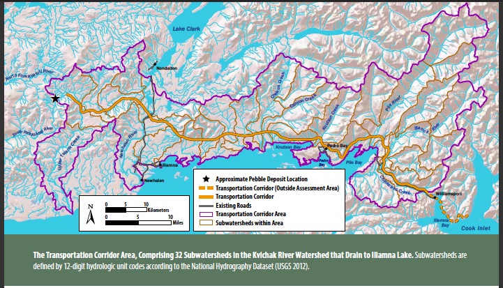
The assessment considers multiple geographic scales. The largest scale is the Bristol Bay watershed, which is a largely undisturbed region with outstanding natural, cultural, and mineral resources. Within the larger Bristol Bay watershed, the assessment focuses on the Nushagak and Kvichak River watersheds. These are the largest of the Bristol Bay watershed’s six major river basins, containing about 50% of the total watershed area, and are identified as mineral development areas by the State of Alaska. Given its size and extent of characterization, the Pebble deposit is the most likely site for nearterm, large-scale mine development in the region. Because the Pebble deposit is located in the headwaters of tributaries to both the Nushagak and Kvichak Rivers, both of these watersheds are subject to potential risks from mining. The third geographic scale is the watersheds of the three tributaries that originate within the potential footprint of a mine on the Pebble deposit: the South Fork Koktuli River, which drains the Pebble deposit area and converges with the North Fork west of the Pebble deposit; the North Fork Koktuli River, located to the northwest of the Pebble deposit, which flows into the Nushagak River via the Koktuli and Mulchatna Rivers; and Upper Talarik Creek, which drains the eastern portion of the Pebble deposit and flows into the Kvichak River via Iliamna Lake, the largest undeveloped lake in the United States. The mine footprints in the three realistic mine scenarios evaluated in the assessment make up the fourth geographic scale. These scenarios—Pebble 0.25, Pebble 2.0, and Pebble 6.5—define three potential mine sizes, representing different stages in the potential mining of the Pebble deposit. The final geographic scale is the combined area of the subwatersheds between the mine footprints and the Kvichak River watershed’s eastern boundary that would be crossed by a transportation corridor linking the mine site to Cook Inlet.
The assessment also addresses two periods for mine activities. The first is the development and operation phase, during which mine infrastructure would be built and the mine would be operated. This phase may last from 20 to 100 years or more. The second is the post-mining phase, during which the site would be monitored and maintained. Water treatment and other waste management activities would continue as necessary and any failures would be remediated. Because mine wastes would be persistent, this period could continue for centuries and potentially in perpetuity.
We began the assessment with a thorough review of what is known about the Bristol Bay watershed, its fisheries and wildlife populations, and its Alaska Native cultures. We also reviewed information about copper mining and publicly available information outlining proposed mine operations for the Pebble deposit. The Pebble deposit has been the focus of much exploratory study and has received significant attention from groups in and outside of Alaska. With the help of regional stakeholders, we developed a set of conceptual models to show potential associations between salmon populations and the environmental stressors that might reasonably result from large-scale mining. Then, following the USEPA’s ecological risk assessment framework, we analyzed the sources and exposures that would occur and potential responses to those exposures. Finally, we characterized the risks to fish habitats, salmon, and other fish populations, as well as the implications of those risks for the wildlife and Alaska Native cultures that use them.
About the US Environmental Protection Agency (EPA)
www.epa.gov
“The mission of EPA is to protect human health and the environment. EPA’s purpose is to ensure that: all Americans are protected from significant risks to human health and the environment where they live, learn and work; national efforts to reduce environmental risk are based on the best available scientific information; federal laws protecting human health and the environment are enforced fairly and effectively…”
 RSS Feed